Map views graphically display wells or base map files on a map. Map views display any wells listed in the collars table as a symbol on the map. Each well in the collars table is displayed as a separate symbol. Wells can display deviation as a line with a symbol at the end of the well or only show the collar location of the well. Wells can be edited as a group or individually. Individual wells can be unchecked in the Object Manager to customize the appearance of the map view. The map also contains a set of four axes, that can be edited individually. Maps can add base layers, such as field outlines or exported Surfer maps, additional well layers, or well selector lines.
All map layers are positioned according to the map layer's coordinate system. Each layer can have a separate source coordinate system. All layers are reprojected into the Map target coordinate system.
Drawing objects and labels can be added to a map view.
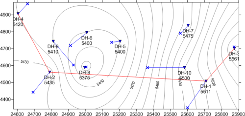
This map view contains wells with names and elevations,
a well selector line, and a contour map loaded as a base map.
New map views in an existing project are created by clicking
the Home | New | Map View command,
clicking the  button, pressing
CTRL+M on the keyboard, or right-clicking in the View
Manager and selecting New Map View.
A new blank map view is created.
button, pressing
CTRL+M on the keyboard, or right-clicking in the View
Manager and selecting New Map View.
A new blank map view is created.
Existing map views are opened by clicking the appropriate Map tab, checking the box next to the map view name in the View Manager, or by selecting Window | [Map name]. By default, the first map view is named Map 1 so this map view would be opened by choosing the Window | Map 1 command. To open an existing project, use the File | Open command.
Create the first map layer with the Map | Create | Well Map or Map | Create | Base Map command.
If creating a well map and a single collars table already has been created, the map view automatically uses that Collars table. If no Collars table exists, you are prompted for the data file. A Collars table is automatically created. If multiple Collars table exist, you are prompted to select one table.
If an existing map has already been created and the well map or base map should be added to the existing map, click the Map | Add | Well Layer or Map | Add | Base Layer commands. If the Create Well Map or Create Base Map command is used and a blank map view is available, the map is created in that map view, otherwise, the map is created in a new map view.
Base maps, additional well maps, and well selector maps can be added to an existing map view. Drawing objects can also be added to a map layer.
See Also