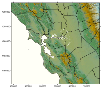
Click the Map | Create | Base Map command to create a new base map. If a blank map view is available, the map is created in that map view, otherwise, the map is created in a new map view. In the Import dialog, select the base map file to import and click Open. The base map is created. Base maps display geographic and political information such as roads, streams, lakes, or state and county boundaries. Base map files draw objects at precise X, Y locations on a map and can contain points, polygons, polylines, text, and images. Base maps can be created from many common map formats, including DXF, SHP, PDF and a variety of image formats.

This base map contains polygons and a background image.
To add a base map to an existing map, click the Map | Add | Base Layer command or right-click on an existing map and choose Add | Base Map. In the Import dialog, select the base layer file to import and click Open. The base layer is added to the map.
If the properties of the base map should be the same as the other objects in the Map, the base map properties can be edited by clicking on the Map in the Object Manager and editing the properties in the Property Manager. This changes the properties for all layers in the map.
If the properties of the base map should be different than other objects in the Map, the Base map layer should be selected. When the properties are edited while the Base layer is selected, all of the objects in the base layer are changed to reflect the new properties.
Some base maps consist of multiple objects (i.e. polygons, polylines, text, etc.). The sub-objects can be selected individually in the Object Manager and edited in the Property Manager.
Base layers have different properties available, depending on the type of objects in the base layer. The possible properties listed in the Property Manager are:
See Also