Collars tables, depth tables, interval tables, lithology tables, project settings tables, survey tables, text item tables, and well construction tables can be created in Strater. Each table type has a different function in Strater. Each table has different default required columns. Although these columns are all created, all of the columns do not need to have data stored in the column to create the logs.
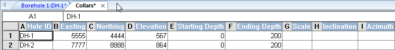
Collars tables contain location information for each borehole. The default column definitions include Hole ID, Easting, Northing, Elevation, Starting Depth, Ending Depth, Scale, Inclination (or Dip), and Azimuth. The data in this table can be used for linked text, setting the scaling parameters for the borehole view, or specifying the elevation of the borehole collar for depth logs. The Inclination (or Dip) and Azimuth columns can be used to calculate true vertical depth for deviated borehole displays. The collars table is also used for placing borehole locations in a map view and for calculating distances in a cross section view.
In a collars table each row contains the information for a separate
borehole. All information for one borehole must be on a single line.
Note that a project can have multiple collars tables, but each borehole should be listed in only a single collars table.
Hole ID |
Contains the borehole ID, one borehole per line. Each borehole should only be listed in a single collars table. |
Required |
Easting |
Contains the X value, easting, longitude, or other horizontal location value of the borehole. |
Required |
Northing |
Contains the Y value, northing, latitude, or other vertical location value of the borehole. |
Required |
Elevation |
Contains the Z value or elevation of the borehole. |
Required |
Starting Depth |
Contains the starting Z value for the borehole in depth or elevation units. This is useful when using the Print Multiple Logs or Export Multiple Logs commands with different boreholes. If all boreholes have the same starting depth, select [0] from the list. |
Required |
Ending Depth |
Contains the ending Z value for the borehole in depth or elevation units. This is useful when using the Print Multiple Logs or Export Multiple Logs commands with different boreholes. |
Required |
Scale |
Contains the Scaling Depth Per Inch value. This is useful when using the Print Multiple Logs or Export Multiple Logs commands with different boreholes. |
Optional |
Inclination |
The angle the borehole is oriented, in degrees. Inclination varies from 0 to 180. 0 indicates vertical pointing down, 90 indicates horizontal, and 180 indicates vertical pointing up. When recorded in a collars table, the azimuth and inclination apply to the entire borehole length. Negative and positive inclination values are treated the same for depth calculations. Negative inclination values are treated differently for well path calculations in the cross section and map views. A negative inclination changes the direction (azimuth) to the opposite of the similar positive inclination. For example, the azimuth value of 90 and inclination of 45 describes the same orientation as the azimuth value of 270 and inclination of -45 degrees. Both combinations describe an eastward direction at 45 degrees down from the horizontal plane. |
Optional |
Dip |
Dip is an alternate method of calculating the angle the borehole is oriented. Dip is oriented in degrees and varies from -90 to 90. -90 indicates vertical pointing down, 0 indicates horizontal, and +90 indicates vertical pointing up |
Optional |
Azimuth |
The compass orientation of the borehole. Azimuth is in degrees and varies from 0 (true vertical north) to 360. When recorded in a collars table, the azimuth and inclination (or dip) apply to the entire borehole length. |
Optional |
Depth tables are used for depth and variable information. The default column definitions include Hole ID, Depth, and additional parameter columns. The depth information is contained in one column. All variable information relates to that specific depth. Depth tables are used for depth, line/symbol, crossplot, bar, percentage, tadpole, post, classed post, and function logs. Depth columns are also used for specifying water levels in a water level table.
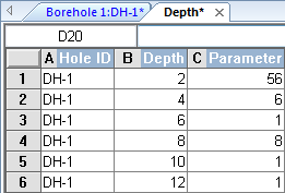
Depth tables include a single depth
measurement and parameter values
associated with that specific measurement.
Hole ID |
Contains the borehole ID associated with the depth. |
Required |
Depth |
Contains the depth or elevation of the recorded parameter. |
Required |
Parameter(s) |
One or more columns that contain information, such as contamination, chemical concentration, etc. The parameter value is recorded at the depth. |
Optional |
Interval tables are used to show a variable that occurs over a distance interval. There are two depth columns (From and To) in an interval table. The default column definitions are Hole ID, From, To, and any additional parameter columns. The interval lengths can vary in the table. Interval tables are used for depth, line/symbol, crossplot, zone bar, bar, percentage, tadpole, post, classed post, complex text, graphic, lithology, well construction, and function logs.
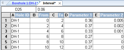
Interval tables measure variables within a defined
interval depth based on From and To measurements.
Hole ID |
Contains the borehole ID associated with the interval. |
Required |
From |
Contains the top depth or elevation of the recorded parameter. |
Required |
To |
Contains the bottom depth or elevation of the recorded parameter. |
Required |
Parameter(s) |
One or more columns that contain information, such as contamination, chemical concentration, etc. The parameter value is recorded across at the interval. |
Optional |
A range table is a special type of interval table. A range table is created when depth-registering an unregistered raster log or when creating a registered raster log. If you have the registration information for a raster log and do not wish to use Strater's depth registration process, you can manually create an interval table and then add the necessary parameter columns. The parameter columns for a range table are described in the following table.
Log Top |
Pixel Y coordinate for the log top in the image. 0 is the top of the image, and the coordinate increases downward. |
Log Bottom |
Pixel Y coordinate for the log bottom in the image. 0 is the top of the image, and the coordinate increases downward. |
Log Left |
Pixel X coordinate for the left edge of the log in the image. 0 of is the left edge of the image, and the coordinate increases to the right. |
Log Right |
Pixel X coordinate for the right edge of the log in the image. 0 is the right edge of the image, and the coordinate increases to the right. |
Raster Log |
Path and file name for the associated image file |
Ref 1 Depth |
Depth value for the reference 1 depth |
Ref 2 Depth |
Depth value for the reference 2 depth |
Ref 1 Pixel |
Pixel Y coordinate for the reference 1 depth |
Ref 2 Pixel |
Pixel Y coordinate for the reference 2 depth |
Lithology tables are a special type of interval table. These tables define the properties of lithology logs using keywords and schemes. The default column definitions include Hole ID, From, To, Lithology Keyword, Lithology Description, Indent Percentage, Indent Keyword, and Indent Scale. Although the primary purpose of a lithology table is to create a lithology log, the lithology table can also be used for depth, line/symbol, crossplot, zone bar, bar, percentage, tadpole, post, classed post, complex text, graphic, well construction, and function logs.
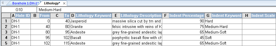
Lithology tables use schemes extensively and describe lithographic features in great detail.
Hole ID |
Contains the borehole ID associated with the interval. |
Required |
From |
Contains the top depth or elevation of the recorded parameter. |
Required |
To |
Contains the bottom depth or elevation of the recorded parameter. |
Required |
Lithology Keyword |
Contains keywords to match the corresponding lithology scheme items. This is usually the rock name. This column is used to create fill patterns for the various interval blocks in the log. |
Required |
Lithology Description |
Contains full text descriptions, typically for the rock type, and can be used for complex text logs. |
Optional |
Indent Percentage |
Contains the percentage of the interval block to display in the left-right direction. The normal range is zero to 100. None of the block is displayed with a zero percentage and 100 percent displays the whole block. The indent percentage can be used to display weathering resistance in a lithological unit. |
Optional |
Indent Keyword |
Contains keywords for the lithology keyword scheme items. The indent keyword can be used to define the shape of the indent line. |
Optional |
Indent Scale |
Controls the overall scaling width of the lithology indent line definition. The range is zero to 100. All values greater than 100 are set to 100 and all values less than zero are set to zero. A zero scale flattens the line and a 100 scale sets the width of the line to half the width of the lithology log. Therefore, if the lithology log is three inches wide, the range of the lithology line represents 1.5 inches. The indent scale should be used with the indent percentage. |
Optional |
The project settings table is a special type of text table. It is used to store project information, such as the project name, project location, project leader, and miscellaneous comments. The default column definitions are Project Name, Company Name, Location, Project Leader, Drilling Date, and Comments. The information stored in this table is for the whole project; it is not borehole specific. This table stores data that is often used in linked text objects.
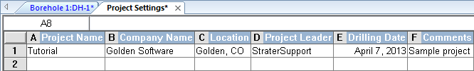
A single row in the project settings table includes all pertinent information for the entire project.
Project Name |
Contains the name or description of the project. |
Required |
Company Name |
Contains the company name or identifying feature. |
Optional |
Location |
Contains the location of the project. |
Optional |
Project Leader |
Contains the name of the person or group leading the project. |
Optional |
Drilling Date |
Contains the date that the project or borehole was started. |
Optional |
Comments |
Contains any additional comments that should be recorded for the project. |
Optional |
Survey tables are a special type of depth table used to indicate the direction and azimuth of a directional borehole as it changes down the hole. The default column definitions include Hole ID, Depth, Inclination, and Azimuth. The survey table Inclination and Azimuth columns can be used for calculating the true vertical depth of boreholes. The survey table is used in conjunction with depth or interval tables for deviated boreholes.
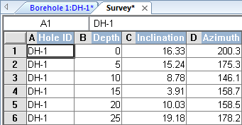
The survey table contains inclination (or dip) and
azimuth information down the borehole.
Note that a project can have multiple survey tables, but each borehole should only be listed in a single survey table.
If deviated boreholes are defined, the inclination (or dip) and azimuth should both come from the same table. The order Strater looks for the inclination (or dip) and azimuth is first measured depth table, then in the survey table, then from a collars table. If inclination (or dip) and azimuth are not found in any location, the measured depth is used as the true vertical depth.
Hole ID |
Contains the borehole ID, one borehole per line. Each borehole should only be listed in a single survey table. |
Required |
Depth |
Contains the depth or elevation for the recorded deviation. |
Required |
Inclination |
The angle the borehole is oriented in degrees. Inclination varies from 0 to 180. 0 indicates vertical pointing down, 90 indicates horizontal, and 180 indicates vertical pointing up. When recorded in a survey table, the azimuth and inclination apply from the depth to the next recorded depth. |
Required |
Dip |
Dip is an alternate method of calculating the angle the borehole is oriented. Dip is oriented in degrees and varies from -90 to 90. -90 indicates vertical pointing down, 0 indicates horizontal, and +90 indicates vertical pointing up |
Required |
Azimuth |
The compass orientation of the borehole's deviation. Azimuth is in degrees and varies from 0 (true vertical north) to 360. When recorded in a survey table, the azimuth and inclination (or dip) apply from the depth to the next recorded depth. |
Required |
Text tables are tables designed to store attributes for the particular borehole. The default column definitions include Hole ID and Depth. Other columns can be added, depending on the project. For example, drilling date, temperature, geologist, location, etc. can be stored in a text item table. Any type of data can be imported into this table. If there is a Hole ID defined in the table, the data can be used for linked text.
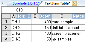
The text item table is a good place to
store miscellaneous information
about the various boreholes.
Hole ID |
Contains the borehole ID associated with the depth. |
Required |
Depth |
Contains the depth or elevation of the recorded text. |
Required |
Text |
One or more columns that contain information, such as contamination, chemical concentration, notes, etc. The parameter value is recorded at the depth. |
Optional |
Well construction tables are a special type of interval table used to define the geometry of specific items in a well construction log, such as casing and cap information. The default column definitions include Hole ID, From, To, Outer Diameter, Inner Diameter, Offset, and Item information. Well construction logs use keywords and schemes to define the properties for each item in the well construction table. You can have any number of well construction tables with different schemes within the project. Although the primary purpose of a well construction table is to create a well construction log, the well construction table can also be used to create depth, line/symbol, crossplot, zone bar, bar, percentage, tadpole, post, classed post, complex text, graphic, lithology, and function logs.
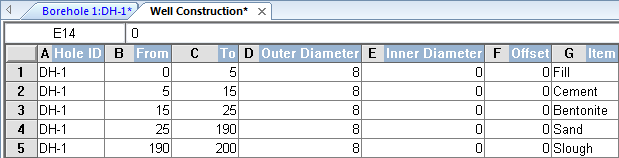
Well construction tables include all information necessary to create well construction logs.
The order in which these items are listed in the table is the order they will be created. Therefore, solid items or items to be layered in the back must be added first in the borehole order.
Hole ID |
Contains the borehole ID associated with the interval. |
Required |
From |
Contains the top depth or elevation of the recorded well construction item. |
Required |
To |
Contains the bottom depth or elevation of the recorded well construction item. |
Required |
Outer Diameter |
Contains the outside diameter of the item. |
Required |
Inner Diameter |
Contains the inside diameter of the item, used to create a cut-out section out of the middle of the items so that the center has no line or fill properties. |
Required |
Offset |
Contains the offset of the item within the well. Positive values move the item away from the center. |
Required |
Item |
Contains the keyword for the well construction scheme items. This is usually the name of the item (fill, cement, screen, etc). |
Required |
You can use math text to alter the appearance or add mathematical concepts or symbols to text entries in a data table. For example, if collar table data or lithology table data is actually displayed in a borehole view you can modify its appearance (or add symbols, etc.) using math text. See Math Text Instructions for detailed information.
See Also