There are multiple methods used to set elevation in Strater. In all of the examples below, the borehole being displayed has a total depth of 200 units from the top of the borehole to the bottom, with a starting elevation of 567 units, based on the Elevation column in the Collars table.
The depth log Orientation option controls only the display of labels on the depth log. Labels can be displayed in elevations or depth down the borehole in Strater. This does not change the "hanging" elevation or convert depths in the cross section to elevation. It only changes the display of the labels on the depth log. The Orientation option uses the starting elevation in the collars table and the data in the data table. This requires you have Elevation values specified in the Collars table.
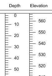
In this example, the data in the depth column has values between 0 and 200. The elevation in the collars column is 567.

Both depth logs are created from the same data.
The log on the left displays depth increasing
down the borehole. The log on the right shows
elevation based on the Collars table Elevation column.
The borehole view properties Orientation option tells Strater if the data in the table is elevation data (increasing upwards) or depth data (increasing downwards). This does change the display of all the logs in the view. However, you must select the appropriate option for the existing data in the data table (so do not select "Elevation" if your data in the data table is really depth data).
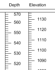
In this example, the data in the depth column has values between 567 and 367. The elevation in the collars column is 567.

When the borehole view properties Orientation is set to Elevation,
the largest value in the data column is displayed at the top of the log and
the values decrease going down the borehole. Note that the depth
log on the right shows elevation values that do not make sense
in this situation. The depth log Orientation should be set to Depth.
The Reference Datum option in the borehole view properties tells Strater whether the data contains depth or elevation. If the data in the data table is really depth data, but you want to see the boreholes in their elevation, set the Reference Datum to Mean Sea Level. That will adjust the logs to be displayed in their real world elevation position, with respect to their elevation in the Collars table. If you do this, you probably want to put the depth log Orientation to Elevation as well. This does require you have Elevation specified in the Collars table.
In this example, the data in the depth column has values between 0 and 200. The elevation in the collars column is 567.

The Reference Datum is set to Mean Sea Level.
See Also