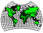
World Map
Van der Grinten Projection
Central Longitude: 0
This projection is typically used for maps of the world and the scale is accurate along the equator. This projection was used by the National Geographic for world maps. The central longitude and the equator are straight lines and the poles are greatly distorted.
To get good results with the Van der Grinten projection, the map must have coordinates between +/-180 degrees longitude and +/- 90 degrees latitude. Surfer does not wrap around +/-180 degrees longitude. The example map is using world-proj.gsb as the base map. If you are using world-scale maps, the central longitude generally cannot be set far from 0 degrees since there is no wrap around in Surfer.
|
Parameter |
Description |
|
Name |
Specifies the units used in the map. |
|
Scale |
Specifies the unit scale of the projected map, relative to meters. For example, a scale of one means one unit in the projected map equals one meter; a scale of two means two units in the projected map equal one meter; etc. |
|
False Easting |
Specifies the false easting, or horizontal offset, of the projected coordinates, in meters. False Eastings and False Northings are added to the underlying "projected" coordinates as a way to arbitrarily offset their internal XY coordinates after the projection. Unless you have a reason for using these offset values, do not use them. These values do not affect the latitude/longitude coordinates for the map, only the internal coordinates used to plot the map on the screen. If you use False Easting and False Northing offsets for a map, any subsequent boundaries you append to the map must also use these same offsets if you want the imported boundaries to be drawn in the correct relative position to the existing boundaries. |
|
False Northing |
Specifies the false northing, or vertical offset, of the projected coordinates, in meters. See above. |
|
Central Longitude |
Specifies the central longitude of the projection in degrees. The Central Longitude value typically should be defined as the longitudinal center of the map you are going to produce. |
See Also
Map Coordinate Systems Overview
Introduction to Map Projections
Source Coordinate System - Map Layer
Target Coordinate System - Map