For maps of the Earth where accuracy is not of particular concern, we can safely assume that the Earth is perfectly spherical in shape. For small-scale maps, the difference between a sphere and ellipsoid is not detectable on the map.
However, the Earth is actually somewhat ellipsoidal (or egg-shaped), approximately 1/300th wider than it is tall, assuming a vertical orientation with respect to the axis of rotation. This shape needs to be taken into account to produce larger scale maps of any significant accuracy.
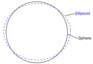
This is an example of an ellipsoid (dashed blue line)
superimposed on a sphere (solid black line).
While an ellipsoid is a closer approximation of the Earth's shape than a sphere, the Earth's surface is not entirely uniform in curvature, so any ellipsoidal representation of the Earth is still only an approximation. This being the case, cartographers have historically used a number of slightly different ellipsoidal representations in attempts to produce more accurate maps of different regions of the Earth.
Ellipsoids are defined by the ellipse being used and by the amount of rotation of the ellipse. An ellipse has two axes. The longer axis is the Semimajor Axis. The shorter axis is the Semiminor Axis. Rotating the ellipse around the semiminor axis creates the ellipsoid.
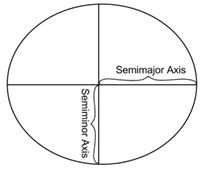
The diagram shows the semimajor and
semiminor axes on an ellipse.
In Strater, the ellipsoid can be defined by the Semimajor Axis and the Semiminor Axis or by the Semimajor Axis and the Inverse Flattening (1/f) value. The flattening value ranges from zero to 1, so the Inverse Flattening (1/f) value must be larger than 1. The flattening value is determined by:
f = (Semimajor Axis - Semiminor Axis)/Semimajor Axis
In the Assign Coordinate System dialog, click the New button to define a new coordinate system. In the Define Coordinate System dialog, the Datum group allows you to specify parameters for the datum. The Ellipsoid can be customized in terms of Name, Semimajor Axis, Semiminor Axis, and Inverse Flattening (1/f). The Semimajor Axis, Semiminor Axis, and Inverse Flattening ratio should be set in meters. If you do not understand ellipsoids and datum definitions, it is recommended you use the defaults. For more information on these subjects, see the projection references.
See Also
Map Coordinate Systems Overview