World Map
Polyconic Projection
Central Longitude: 0
Central Latitude: 0
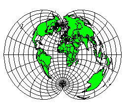
The Polyconic projection is useful for maps of continental or smaller regions. Generally, this projection is not used for world maps due to extreme distortion at any significant distance from the center of the projection. Only the central meridian is distortion-free. Notice in the sample map shown above that Africa is relatively undistorted, but the rest of the world is barely recognizable. Scale is true along the central longitude and along each parallel.
|
Parameter |
Description |
|
Name |
Specifies the units used in the map. |
|
Scale |
Specifies the unit scale of the projected map, relative to meters. For example, a scale of one means one unit in the projected map equals one meter; a scale of two means two units in the projected map equal one meter; etc. |
|
False Easting |
Specifies the false easting, or horizontal offset, of the projected coordinates, in meters. False Eastings and False Northings are added to the underlying "projected" coordinates as a way to arbitrarily offset their internal XY coordinates after the projection. Unless you have a reason for using these offset values, do not use them. These values do not affect the latitude/longitude coordinates for the map, only the internal coordinates used to plot the map on the screen. If you use False Easting and False Northing offsets for a map, any subsequent boundaries you append to the map must also use these same offsets if you want the imported boundaries to be drawn in the correct relative position to the existing boundaries. |
|
False Northing |
Specifies the false northing, or vertical offset, of the projected coordinates, in meters. See above. |
|
Central Longitude |
Specifies the central longitude of the projection in degrees. The Central Longitude value typically should be defined as the longitudinal center of the map you are going to produce. |
|
Central Latitude |
Specifies the central latitude of the projection in degrees. The Central Latitude value typically should be defined as the latitudinal center of the map you are going to produce. |
See Also
Map Coordinate Systems Overview
Introduction to Map Projections
Source Coordinate System - Map Layer
Target Coordinate System - Map
Characteristics of Projections