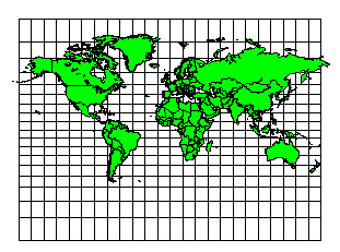
World Map
Miller Cylindrical Projection
Central Longitude: 0
Scale is constant along any given parallel and accurate along the equator in a Miller Cylindrical projection. Scale is the same in all directions near any given point. Miller Cylindrical projection maps use variable latitudinal scale as a way to minimize distortion as you move north or south from the equator. The method effectively corrects for the relative distances covered by one degree of longitude relative to one degree of latitude as you move away from the equator. Distortion is minimal near the equator, but becomes extreme toward the poles. Miller Cylindrical maps do not represent relative land areas accurately, but do approximate the relative shapes of individual land areas. Miller Cylindrical projection maps are useful for displaying the entire world.
|
Parameter |
Description |
|
Name |
Specifies the units used in the map. |
|
Scale |
Specifies the unit scale of the projected map, relative to meters. For example, a scale of one means one unit in the projected map equals one meter; a scale of two means two units in the projected map equal one meter; etc. |
|
False Easting |
Specifies the false easting, or horizontal offset, of the projected coordinates, in meters. False Eastings and False Northings are added to the underlying "projected" coordinates as a way to arbitrarily offset their internal XY coordinates after the projection. Unless you have a reason for using these offset values, do not use them. These values do not affect the latitude/longitude coordinates for the map, only the internal coordinates used to plot the map on the screen. If you use False Easting and False Northing offsets for a map, any subsequent boundaries you append to the map must also use these same offsets if you want the imported boundaries to be drawn in the correct relative position to the existing boundaries. |
|
False Northing |
Specifies the false northing, or vertical offset, of the projected coordinates, in meters. See above. |
|
Central Longitude |
Specifies the central longitude of the projection in degrees. This value should be defined as the longitudinal center of the map you are going to produce. This value is only significant when you define False Easting and False Northing values and it has no apparent effect on the map. |
See Also
Map Coordinate Systems Overview
Introduction to Map Projections
Source Coordinate System - Map Layer
Target Coordinate System - Map
Characteristics of Projections