Creating Deviated Boreholes in a Cross Section View - Tutorial
To create the deviated boreholes in the cross section view, a new cross
section view must be created with the wells to be displayed. The properties
of the cross section are then edited to display the deviations from the
survey table.
Creating the Cross Section
Click
the Home | New
| Cross Section View command or click the  button to open a new cross
section view.
button to open a new cross
section view.
Click
the Cross Section | Create/Add |
Create Cross Section command to create a new cross
section.
In
the Create Well
Selector dialog,
Click on the T-4 well
in the Wells in selector
list. Click and hold the left mouse button and drag the T-4 well
to the top of the list.
Click on the T-45
well in the Wells in selector
list. Click and hold the left mouse button and drag the T-45 well
to the bottom of the list.
Click
OK.
In
the Import
Cross Section Data dialog, notice that Lithology/Zone
bar log is selected and that each Hole
ID has a Table and
Data Column defined. Click
OK.
To
show the well labels, click the Cross
Section | Create/Add | Add Well Headers command.
The cross section is created,
showing a lithology log for each well and the connecting layers between
wells.
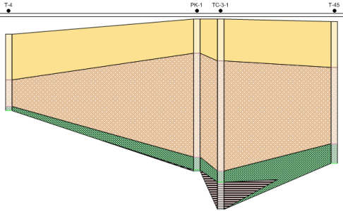
The original cross section is created with the wells
displayed as vertical.
Displaying the Cross Section with Deviated Wells
To change the wells so that the deviation paths are displayed, the Logs layer, Cross
Section object, and cross section View properties need to be edited.
Click on the Logs
item in the Object Manager.
In the Property
Manager, click on the Logs
tab.
Set the Hole
Inclination Column to [From
survey table]: Survey.
Notice that the Hole Azimuth Column automatically
changes to the survey table.
Click on the Cross
Section object in the Object
Manager.
On the Cross
Section tab, check the box next to the Display
Logs As Deviated option.
If desired, click Yes in the dialog so that
the Depth Method is
automatically set to True
Vertical Depth. Alternatively, click No
and set the Depth Method
manually.
Click
the View
| Display | View Properties command.
Click
on the View tab in the
Property Manager.
Set
the Depth Method to True Vertical Depth.
If prompted to recreate
the cross section, click Yes
and the deviated wells are displayed in the cross section view.
The cross section is updated showing the deviations for the wells.

The wells in the cross section are updated to show the
deviations.
Back to Creating
Deviated Boreholes in a Map View
Back to Tutorial
Introduction
Congratulations! You have now completed all of the advanced tutorial
lessons.