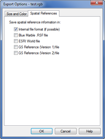
Some applications associate spatial reference information (such as projection, datum, and georeference parameters) with files, to link the file to a specific region of the Earth’s surface. If the map that you are exporting has a coordinate system defined, the Spatial References tab will appear in the Export Options dialog.

The Spatial References page allows you to choose how to save
the projection, datum, and georeference information.
Most bitmap file storage formats don’t have a way to store the spatial reference information in the same file as the bitmap image. For these formats, the only way the spatial reference information can be saved is in a separate file.
Internal File Format (if Possible)
If the export format can internally store the georeference information, check this box. The spatial reference information will be stored (along with the image) in the selected format. One format that stores the coordinate reference is a TIF file, a vendor-independent format that can be imported into a variety of geographic software packages.
Blue Marble .RSF File
Blue Marble Geographics supports a text-based format for storing georeference information in a separate file. Various Blue Marble programs will import the information in this file when importing the bitmap file. This option is not available for vector format exports.
Esri World file
Environmental Sciences Research Institute (Esri) supports a text-based format for storing georeference information in a separate file. Various Esri programs will import the information in this file when importing the bitmap file. The first and third characters of the image file’s suffix, plus a final "w", are used for the world file suffix. Therefore, "mytown.tif" will have a world file called "mytown.tfw"; for "redlands.bmp", it will be "redlands.bpw". This option is not available for vector format exports.
Esri .PRJ File
Environmental Sciences Research Institute (Esri) supports a text-based format for storing georeference information in a separate file. Various Esri programs will import the information in this file when importing vector files, such as .SHP files.
GS Reference (Version 1) File
Golden Software supports a text-based format for storing spatial reference information in a separate file. Projection, datum and georeference information can be stored in this format. The file will be created having the same name as the exported bitmap, with the suffix ".GSR" appended. The .GSR file is an older format Golden Software reference file.
GS Reference (Version 2) File
Golden Software's .GSR2 file is a newer georeference file format that includes spatial reference information in a separate file. The .GSR2 file is always exported when the selected object is georeferenced. Projection, datum and georeference information can be stored in this format. The file will be created having the same name as the exported bitmap, with the suffix ".GSR2" appended.
See Also