The File | Export Data | XYZ Data command creates a data file with the Hole ID, X, Y, and Z coordinates of the true vertical depth. This command is available for all table types except collars tables.
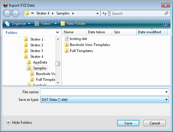
After clicking the File | Export Data | XYZ Data command, the Export XYZ Data dialog appears. Type a File name and click Save.
Type a File name to save the calculated borehole locations to an XYZ data file.
The Export XYZ Data dialog appears.
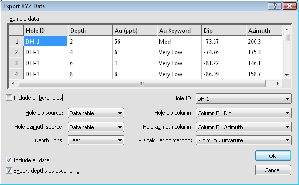
Set the inclination (or dip), azimuth, and TVD calculation method and click OK.
The Sample data section contains a portion of the table. The top line contains the header row, for ease in setting the inclination (or dip), azimuth, and hole ID columns.
Check the box next to Include all boreholes to calculate the true vertical depth for all boreholes in the table. When the box is not checked, the Hole ID option becomes available.
When the Include all boreholes option is not checked, the Hole ID option becomes available. Click on the existing borehole name and select the appropriate borehole from the list. Only the selected borehole's true vertical depth is calculated.
The Hole inclination source or Hole dip source contains the source of the inclination or dip column. Click on the existing table name and select the desired table from the list. Available options are None, Collars table, Data table, and Survey table. Setting the option to None does not calculate the true vertical depth. The Collars table option reads all collars tables in the project and selects the appropriate inclination column for each borehole. The Survey table option reads all survey tables in the project and select the appropriate inclination or dip column for each borehole. Set the source to Data table to read the Hole inclination column or Hole dip column from the currently selected table. The Hole inclination column or Hole dip column option becomes available.
If either the Hole inclination source, Hole dip source, or Hole azimuth source is set to Survey table, both sources are set to Survey table.
When the Hole inclination source or Hole dip source is set to Data table, the Hole inclination column or Hole dip column option is available. Click on the existing column name and select the column that contains the inclination or dip information from the list.
The Hole azimuth source contains the source of the azimuth column. Click on the existing table name and select the desired table from the list. Available options are None, Collars table, Data table, and Survey table. Setting the option to None does not calculate the true vertical depth. The Collars table option reads all collars tables in the project and selects the appropriate azimuth column for each borehole. The Survey table option reads all survey tables in the project and select the appropriate azimuth column for each borehole. Set the source to Data table to read the Hole azimuth column from the currently selected table. The Hole azimuth column option becomes available.
If either the Hole inclination source, Hole dip source, or Hole azimuth source is set to Survey table, both sources are set to Survey table.
When the Hole azimuth source is set to Data table, the Hole azimuth column option is available. Click on the existing column name and select the column that contains the azimuth information from the list.
The Depth units option determines the units used in the exported data file. By default, the Depth units are set to the same units as the units on the Depth column. Changing the Depth units allows a data file to be created with a different unit, such as meters instead of feet.
The TVD calculation method is the method used to calculate the true vertical depth. Refer to the True Vertical Depth Calculation Methods page for information on each method.
Check the box next to Include all data to include all data in all columns in the existing table in the exported data file. Uncheck the box to only export the Hole ID and X, Y, and Z coordinates.
When a data table contains depth values that increase down the borehole, checking the box next to Export Depths as Ascending will make the depth values negative, so that the values increase up. This is useful when working in other programs, such as Voxler, Surfer, or Grapher with the exported data. As an example, a borehole that ranges from 0 at the top of the borehole to 2400 at the bottom of the borehole will be exported as 0 to -2400 when this option is checked.
Click OK to calculate the true vertical depth values and create the new data file. Click Cancel to exit out of the dialog without creating the data file.
The data file that is created contains at least four columns: X, Y, Z, and Hole ID. If the Include all data option is checked, other columns may exist.
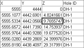
The data file created contains four columns, with
XYZ location information for each point along the borehole.
The X, Y Z columns are calculated by transforming the measured depth along the borehole with the azimuth and inclination values to create the true vertical depth.
See Also