A Wells layer contains the wells and well selector lines in the map. The wells that appear are in the same collars table. Wells maps are created with the Map | Create | Well Map command. Additional Wells layers can be added to the existing map with the Map | Add | Well Layer command.
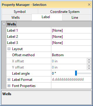
To edit the labels displayed on the Wells layer, click on the Wells map layer in the Object Manager. The Wells properties are listed in the Property Manager. Click on the Label tab to display labels for all wells and change the label properties.
To move the label for an individual well, click on that well name in the Object Manager. Then, set the Label Layout in the Property Manager.
Display well ID labels, coordinate labels, or any column
from the collars table as labels on the Wells map layer.
Each well can have up to three different labels. To display a label, click on the existing option and select the desired label from the list. Available options are [None], Coordinates, Hole ID, and all columns listed in the collars table on the Wells tab for the well location map. If no labels are desired, set Label 1, Label 2, and Label 3 to [None]. Select Coordinates to display the X and Y coordinates for all wells on the Wells layer. The coordinates are shown as (X,Y) for each well. Select Hole ID to show the well name for each well. Select any of the other columns to display labels from that column for each well.
Click the  next to Layout to open the Layout section. This section positions
the labels around the wells.
next to Layout to open the Layout section. This section positions
the labels around the wells.
The Offset method lists the locations around the wells where the labels are positioned. Available options are Center, Left, Top, Right, Bottom, or User defined. To change the position, click on the existing option and select the desired location from the list.
The X offset and
Y offset control how far
away the labels are drawn from the well location when the Offset method is set to User
defined. Changing the X offset
moves the labels horizontally. Changing the Y
offset moves the labels vertically. Positive values move the labels
right and up on the page. The offset amount is in page units and refers
to the location away from the well location where the center of the labels
will be located. To change the value, highlight the existing value and
type a new value or click the ![]() to increase
or decrease the distance from the well. Values are between -2 and 2 inches.
to increase
or decrease the distance from the well. Values are between -2 and 2 inches.
The Label angle option specifies
the angle at which the labels are drawn. Positive angles rotate label
in a counterclockwise direction. Values must be between 0 and 360 degrees.
To change the Label angle, highlight
the existing value and type a new number or click the ![]() to increase or decrease the angle.
to increase or decrease the angle.
Click the
next to Label Format
to open the numeric format
properties section. The format properties apply to all of the well
labels in the Wells map layer.
Click the
next to Font Properties to open
the font properties section.
The font properties apply to all of the well labels in the Wells
map layer. The size, color, text properties and horizontal alignment of
the multiple lines of labels can be set. If the options in the font properties
section are not available, click on the Wells
tab and uncheck the box next to the Use
keyword scheme for label font option.
See Also
Wells - Coordinate System Properties